The Chemin des Dames battlefield is frequently overlooked by English-speaking visitors. That is unfortunate. The Germans had been ensconced on an 18-mile irregularly-shaped ridgeline that overlooked the Aisne valley for almost three years.  During their occupation, they prepared extensive defensive positions both on the ridge and in caves and tunnels dug into the sides of the hills. The French Army decided to attack those strongpoints in April 1917. Everything was against their success; the strategic plan, the terrain, and the weather. The Nivelle Offensive was a disaster for the French, costing them almost 200,000 casualties and inciting a widespread army mutiny. Continue reading
Category Archives: Battlefield
Battle of Patay
After the liberation of Orléans, Jeanne d’Arc turned her attention to other English-held towns in the Loire Valley. While far-less-known than the famous royal châteaux, these villages offer opportunities to view medieval castles and churches of a simpler style. Wandering their narrow streets can sometimes present quaint sights of life in rural France.
03a Battle of Patay: 18 June 1429
Département: Loiret
Region: Centre
Country: France
A French Battlefields “Virtual Battlefield Tour” [This battlefield is not included in Fields of War.]
Summary: The siege of Orléans had been lifted, but the English Army, led by John Talbot, the 1st Earl of Shrewsbury, still controlled bridges across the Loire River at Jargeau, Meung-s/Loire, and Beaugency. In addition, Sir John Fastolf was leading an English relief column from Paris. After a short rest and with reinforcements in the form of Duke Jean II of Alençon’s troops, Jeanne set about retaking Jargeau (12 June), the Meung-s/Loire bridge (15 June) and Beaugency (16 June). The combined French forces pursued the retreating English Army and won a decisive open-field battle near Patay (18 June). The victory turned the tide of the war.
View 03a Battle of Patay: 18 June 1429 in a larger map
Siege of Orléans
03 Siege of Orléans: 12 October 1428 to 8 May 1429
Département: Loiret
Region: Centre
Country: France
A French Battlefields “Virtual Battlefield Tour”. This battle is more fully described in Fields of War: Fifty Key Battlefields in France and Belgium published by French Battlefields.
Summary: Orléans controlled one of the few bridges crossing the dangerous Loire River, a major commercial waterway. Capture of the city offered the English control of the entire Loire valley. The walled city was placed under siege by the Earl of Salisbury’s forces and, as winter changed into spring, the inhabitants were increasingly weakened by shortages of food and desertions. Jeanne d’Arc, then only a 17-year old peasant girl, convinced the French Dauphin to grant her an army to lift the siege. Personally leading successive attacks, she entered the city, stormed various English strongpoints, and finally overcame Les Tourelles. The siege was lifted.
View 03 Seige of Orleans in a larger map
Irish Guards Monument Moved
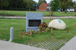
 The plaque commemorating the capture on 10 September 1944 of ‘Joe’s Bridge’ by the Irish Guards has been relocated. For years the plaque dedicating the bridge to the group’s commander, Lieutenant-Colonel J.O.E. Vandeleur DSO, was posted below the bridge’s northeastern ramp. This summer the plaque was fitted upon a new stone and relocated to a park on the other side of the Maas – Schelde Canal (Bocholt – Herentals Kanaal) southeast of the bridge. The slip road to the park can only be entered by driving north on the N715 from Overpelt, Belgium towards Valkswaard, Netherlands.
Battle of Agincourt
02 Battle of Agincourt: 25 October 1415
Département: Pas-de-Calais
Region: Nord-Pas-de-Calais
Country: France
A French Battlefields “Virtual Battlefield Tour”. This battle is more fully described in Fields of War: Fifty Key Battlefields in France and Belgium published by French Battlefields.
Summary: Henry V became King of England in 1413. A professional soldier, he almost immediately began preparations to invade France, then embroiled in a nasty civil war between Armagnac and Orleanist factions. Henry landed his forces near the port of Harfleur and began a five-week siege. Henry’s army, weaken by the siege, illness, and shortages of supplies, made to escape to the English stronghold at Calais. After days of maneuvering as the English attempted to cross the Somme River, the larger French army, led by the Constable of France, Charles d’Albret, blocked the road to Calais at the town of Agincourt (Azincourt). Outnumbered in men-at-arms by over 10 to 1, Henry established positions on open ground flanked by his archers. Again, as at Crecy, the superior firepower of the longbow and poor tactics by the French resulted in a stunning English victory.
View 02 Battle of Agincourt in a larger map
